With more than 1.1 million acres burned, the Smokehouse Creek Fire in the Texas Panhandle is now the largest wildfire in the state’s history. The uncontained blaze has forced evacuations from hundreds of homes, cattle ranches and businesses and caused two deaths. A combination of dry conditions, unseasonably warm weather and strong winds has fueled the fire, which began Feb. 26.
The “state’s history” of wildfires goes all the way back to 2005.
Fire Statistics
The historical data reflects wildfire response for Texas A&M Forest Service and local fire departments*. Prior to 2005, official wildfire data was not captured using current reporting methods. There is no official data prior to 2005 posted on this site.
The data support the exact opposite of a trend of increasing wildfire damage.
The USA Today is historically most well known for its flashy graphics. And the Texas wildfire article was no disappointment here. The article included this image of the Smokehouse Creek Fire on a map of North Texas and the Panhandle.
As a geologist, who lives in Dallas and works in Houston, this provided all of the scale and context that I needed. The fire was about 300 miles (as the crow flies) from our home in Dallas. The map has a scale bar in the bottom left corner.
In all of their lack of wisdom, the USA Today decided that a total lack of scale and context was needed
For a size comparison, this is what the burn area of the Smokehouse Creek Fire would look like compared to the state of Connecticut:
Rather than using a scale bar, the authors used an outline of the state of “Connecticut for scale.”
As a geologist and “naturalized” Texan, who was born, raised and educated in the formerly great state of Connecticut, I found this map to be particularly hilarious. The Smokehouse Creek Fire was VERY big and Connecticut is VERY small.
The city of Houston, Texas would cover most of Connecticut.,
As would the Dallas-Fort Worth Metroplex (DFW)…
As if this wasn’t funny enough, USA Today also threw in the good old Manhattan decoy:
This is even sillier than Manhattan-sized icebergs calving off of Greenland.
Scale and context
The Smokehouse Creek Fire was very big.
Texas is much bigger than the Smokehouse Creek Fire.
Connecticut is very small.
Houston is almost as big as Connecticut.
DFW is almost as big as Connecticut.
Manhattan is even smaller than Connecticut.
The purpose of scale is to provide context. A 1.2 million acre wildfire is VERY big. In the Texas panhandle, it killed three people, thousands of livestock, destroyed dozens of homes and caused nearly $5 billion in damage. Had a similar sized fire occurred in Connecticut, it would have essentially destroyed the entire state.
Placing the area of the fire on a map of Connecticut is the exact opposite of using scale to provide context.
Searching for causes in all the wrong places
NOAA’s analysis struggled to pin this on climate change…
Climate context of the February 2024 megafire outbreak in Texas
By Rebecca Lindsey Reviewed By Todd Lindley
Published March 7, 2024
In the last week of February 2024, a record-setting fire outbreak charred its way through the northern panhandle of Texas. Climatologically speaking, it was right on time: the grasslands of the southern Great Plains historically face their highest fire risk in late winter and early spring. Grasses are still dormant and dry, but temperatures are starting to climb.
Satellite image of burned areas (reddish brown) north of Amarillo, Texas, on March 2, 2024. Olive-brown areas are grass-dominated landscapes where vegetation is dormant for the winter. In the fire area, the bright green vegetation is irrigated fields. NASA Earth Observatory image.
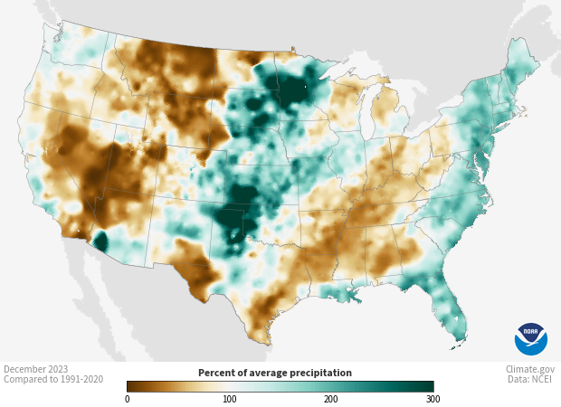
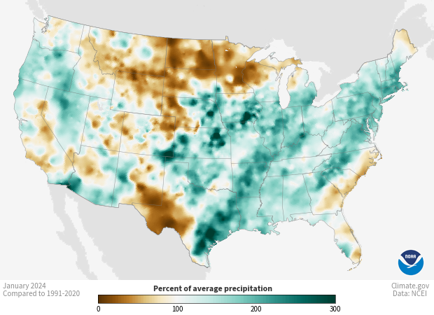
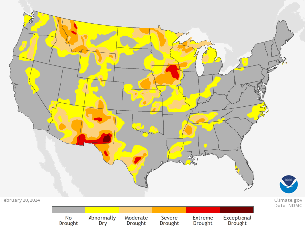
Aside from the timing, though, the outbreak of megafires—those larger than 100,000 acres—was something of a surprise from a climate perspective. Historically, Texas’ worst fire seasons have occurred following La Niña winters, which tend to be warmer and drier than average across the southern United States. This winter, by contrast, has been under the influence of El Niño, and the northern panhandle of Texas was wetter than average in December and January. That pattern did change in February, but even so, the February 20 Drought Monitor map was empty of drought or even “abnormally dry” conditions in the area where the outbreak began on February 26.
But that’s the thing about fire in the Southern Plains that can be counterintuitive, explains Todd Lindley, a NOAA forecaster who specializes in fire weather on the Southern Plains. “Here, a very deep drought actually reduces the fine fuel loading on the landscape.” What’s more dangerous is a wet spring and summer growing season. “You grow more grass, and then you get into the winter and [early] spring dormant season, and those fine fuel loadings are vulnerable to fires.”
[…]
Fire suppression and climate change in the Southern Plains
Like other parts of the West, a century of fire suppression policies have left the Southern Plains with an excess of fuels. Lindley says, “The fire suppression has allowed an invasion of short, woody species like eastern red cedar and mesquite. What used to be well-managed by Native Americans as a grass prairie is becoming more of a mixed ecosystem, with grass that facilitates very rapid fire spread, but you also have these low-canopy wooded species that increase the fire intensity dramatically.”
There’s no denying the impact these choices have had on fire behavior in the Southern Plains. Says Lindley. “We had over-suppression for well over a century, and now, even though if you look at the total number of fires, they’re on a decline, but the fires that we do get, are growing in size and intensity almost exponentially.”
The legacy of fire suppression is a key part of the story. At the same time, the late February weather system that primed the prairie for fire had at least one stand-out characteristic: heat. “On Monday, the 26th,” says Lindley, “when the fires initiated, we were seeing record-high temperatures across central and west Texas and western Oklahoma.”
Without a specific type of analysis called extreme event attribution, it’s impossible to say exactly how much influence long-term global warming had on this event. But we know winters in North and West Texas are getting warmer, and new heat records are being set more frequently today than they used to be.
[…]
As far as other ways climate change might have affected fire ingredients, things aren’t as clear cut as they are for temperature. Says Nielson-Gammon, “Overall rainfall trends are almost zero in the Texas Panhandle, so climate change probably didn’t affect the amount of fuels from a rainfall perspective.”
[Cue the non sequitur.]
Protecting people, livestock, and property in a warmer world
The ultimate solution to increases in dangerous fire weather is to stop global warming; the world must bring the net amount of greenhouse gases that we release into the atmosphere down to zero.
“The ultimate solution to increases in dangerous fire weather is to stop global warming”
What if the “increases in dangerous fire weather” aren’t causing an increase in wildfire destruction?
In a paper published in Science, researchers note this same trend: “Unexpectedly, global burned area declined by ∼25% over the past 18 years, despite the influence of climate.”5 They, too, point out that this is largely driven by a decline in burn rates in grasslands and savannas as a result of the expansion and intensification of agriculture.
The usually reasonable John Nielson-Gammon nearly went full Andrew Dessler over this…
In Texas, a powerful combination of dry land and high winds fuels wildfires
One climatologist called the situation “like a hurricane making landfall at high tide.” Fires raced across the landscape so quickly that firefighters had little chance to contain them.
Abnormally warm temperatures, dry grasses and a sudden windy cold front combined to create the conditions for the destructive wildfires that have raged across parts of Texas this week.
The winds that sent wildfires charging across the Texas Panhandle struck at the perfect time of day for destruction, “like a hurricane making landfall at high tide,” Texas State Climatologist John Nielson-Gammon said. Hot, dry temperatures — the kind that can be spurred by climate change — helped create conditions for those fires to take off, he added.
On Monday, temperatures in some parts of the dry northern region of the state reached the mid-80s, and several wildfires began to burn.
The next day, Arctic air plunged down from the north in a bitter cold front. Winds on both sides of that front — which exceeded 50 mph at times — sent flames roaring through dormant grasses, Nielsen-Gammon said. The cold front arrived in the late afternoon, when wind speeds were highest, and also changed directions as it passed through, maximizing how quickly the fire spread.
Xcel Energy on Thursday acknowledged its involvement in the Smokehouse Creek fire, which started last week and quickly became the largest wildfire in state history, burning more than 1 million acres.
“Based on currently available information, Xcel Energy acknowledges that its facilities appear to have been involved in an ignition of the Smokehouse Creek fire,” the company said in a statement Thursday.
Xcel said it has been cooperating with investigations into the wildfires and conducting its own review of the incident since it started. However, the company disputed claims in the same statement that the company acted negligently in maintaining and operating its infrastructure.
[…]
Xcel Energy’s subsidiary Southwestern Public Service Company serves the area where the fire is burning, according to the SEC filing. The location is outside of the jurisdiction of the Electric Reliability Council of Texas, which operates the power grid that provides electricity for most of the state.
According to Xcel’s statement, 47 homes in Hemphill County and up to 17 homes in Roberts County were destroyed by the fire.
Can’t blame ERCOT for this one… Fallen power lines, due to improperly maintained utility poles outside of the jurisdiction of ERCOT, caused the fire.
Decayed power pole sparked the largest wildfire in state history, Texas House committee confirms
By The Texas Tribune, Jayme Lozano Carver
Thursday, May 2, 2024
LUBBOCK, Texas (KTRK) — A decayed utility pole that broke, causing power wires to fall on dry grass in the Texas Panhandle, sparked the state’s largest wildfire in history, a Texas House committee confirmed Wednesday.
The committee also found that a lack of readily available air support, ineffective communication from faulty equipment and coordination among agencies inhibited on-the-ground efforts to contain the Smokehouse Creek fire and others that ravaged the Panhandle earlier this year.
It seems to me that, rather than trying to “stop global warming,” the “ultimate” solution would involve: 1) the “expansion and intensification of agriculture,” 2) fire suppression policies that don’t result in an “excess of fuels,” 3) proper maintenance and operation of electrical transmission infrastructure, and 4) improved coordination of firefighting resources… But this would require an actual grasp of scale and context.
We use cookies on our website to give you the most relevant experience by remembering your preferences and repeat visits. By clicking “Accept All”, you consent to the use of ALL the cookies. However, you may visit "Cookie Settings" to provide a controlled consent.
This website uses cookies to improve your experience while you navigate through the website. Out of these, the cookies that are categorized as necessary are stored on your browser as they are essential for the working of basic functionalities of the website. We also use third-party cookies that help us analyze and understand how you use this website. These cookies will be stored in your browser only with your consent. You also have the option to opt-out of these cookies. But opting out of some of these cookies may affect your browsing experience.
Necessary cookies are absolutely essential for the website to function properly. These cookies ensure basic functionalities and security features of the website, anonymously.
Cookie
Duration
Description
cookielawinfo-checkbox-analytics
11 months
This cookie is set by GDPR Cookie Consent plugin. The cookie is used to store the user consent for the cookies in the category "Analytics".
cookielawinfo-checkbox-functional
11 months
The cookie is set by GDPR cookie consent to record the user consent for the cookies in the category "Functional".
cookielawinfo-checkbox-necessary
11 months
This cookie is set by GDPR Cookie Consent plugin. The cookies is used to store the user consent for the cookies in the category "Necessary".
cookielawinfo-checkbox-others
11 months
This cookie is set by GDPR Cookie Consent plugin. The cookie is used to store the user consent for the cookies in the category "Other.
cookielawinfo-checkbox-performance
11 months
This cookie is set by GDPR Cookie Consent plugin. The cookie is used to store the user consent for the cookies in the category "Performance".
viewed_cookie_policy
11 months
The cookie is set by the GDPR Cookie Consent plugin and is used to store whether or not user has consented to the use of cookies. It does not store any personal data.
Functional cookies help to perform certain functionalities like sharing the content of the website on social media platforms, collect feedbacks, and other third-party features.
Performance cookies are used to understand and analyze the key performance indexes of the website which helps in delivering a better user experience for the visitors.
Analytical cookies are used to understand how visitors interact with the website. These cookies help provide information on metrics the number of visitors, bounce rate, traffic source, etc.
Advertisement cookies are used to provide visitors with relevant ads and marketing campaigns. These cookies track visitors across websites and collect information to provide customized ads.


